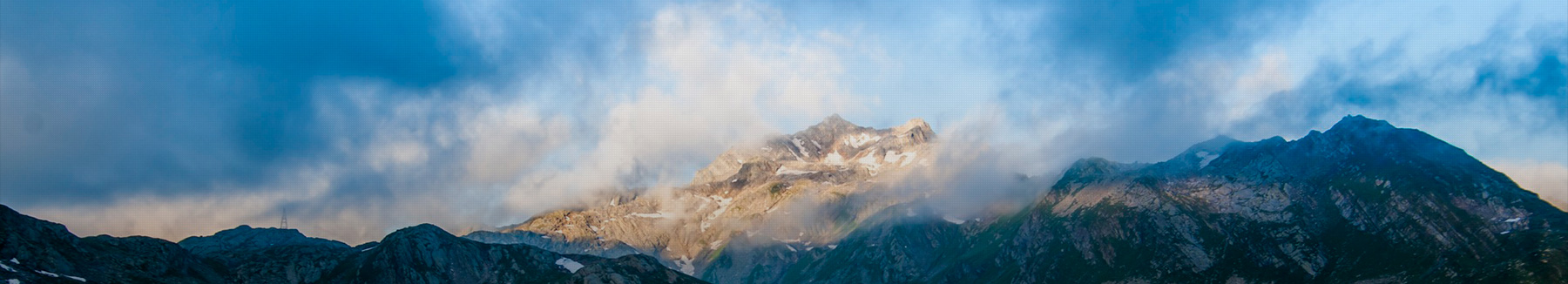
LANGTANG VALLEY TREK, AFTER EARTHQUAKE. STILL POSSIBLE
Langtang National Park was the third most popular trekking region in Nepal after the Annapurna and Everest regions. This changed considerably after the devastating earthquake that hit Nepal on the 28th of April 2015.
Langtang Valley is now considered to be ground zero of the earthquake.
Just a few days after the earthquake the already damaged village of Langtang was hit by an enormous landslide and got completely swept away. And just like that, the biggest village of the region ceased to exist.
There’s been a lot of rumors and lies online on the world’s biggest traveling forums and guidebooks, that since the earthquake happened the Valley is closed for trekking.
That’s complete rubbish!!! The Valley is open for trekking!!
The locals that still live in the Valley were almost begging us to tell our friends and other tourists we met that Langtang Valley is 100% open for business.
The locals say that the only way they can continue their life is if tourists come back to Langtang Valley.
And I did meet a few other hikers on the trek plus a few porters carrying building materials up the Valley.
I got some new and updated information from a Reece,:
I completed the trek on the 21st of May 2016. The lower path from Syabrubesi to Renche is now open. There are 2 lodges in Langtang that are open with a couple more that looked pretty close aswell. In Kyanjin gompa about 10 lodges are open at the moment. Hopefully this helpsDay 1. Kathmandu – SyapruBesi, Bus.
The fast tourist bus from Kathmandu to SyapruBesi stopped running just days after the earthquake happened.
The only direct bus these days leaves at 8 am across the Buddha Mall in Kathmandu.
The price is 700rps and it takes about 7 hours including a 40min lunch stop in Nuwakot.
The road is surprisingly good compared to the average Nepali road, with only a section before Dunche being bumpy.
There’s Two, TIMs card and permit checkpoints Dunche.
You will arrive in SyapruBesi around 3 pm. So you will most likey spend the first night in SyapruBesi since it’s about two hours of climbing to the next place with accommodation.
DAY 2. SYAPRUBESI (1503M) – KANGJIM (2228M) – SHERPOGAN (2563M) 5,5-6 HOURS WALK.
Since the new path along the river got destroyed by the earthquake, now the only option to reach the Langtang Valley is the old high path trough the small village of Kangjim.
You start the day off with walking trough SyapruBesi, just following the road that leads to Tibet, but instead if going to the “Forbidden Kingdom” you have to turn right just after a military checkpoint, where they will check your TIMs card once again.
That path continues across a small hanging bridge before you start climbing, first will you reach the now completely broken village of “Wanga”, the village is no more than a pile of rocks after the earthquake.
After Wanga will you follow a newly built jeep road almost all the way to “Kangjim” that you will reach after about an hour after Wanga.
Khangjim has a few guesthouses and is an ideal place to stop for lunch.
The path continues up, and more up for another 2 hours until you reach the highest point of the day, a small pass at 2725m.
After the pass you’ll still have another 1.5 hours of easy walking trough a pine forest and along a ridge until reaching the small village of “Sherpogan” at 2563m. Sherpagon has 5 guesthouses.
The high road to Sherpagaon
DAY 3. SHERPAGON (2563M) – RIMCHE (2399M) – LAMA HOTEL (2410M) – HOTEL WOODLAND (2790M) – MUNDU (3543M) 8.5 -9 HOURS.
All the places mentioned above are unharmed by the earthquake and should have open guesthouses for the 2016 season. The places that are not mentioned are totally gone, including Langtang Village.
Since most of the settlements in Langtang Valley are gone, it turned out to be a very long day of hiking.
Rimche, Llama Hotel, and Hotel Woodland were all standing strong but were closed at the time I passed trough. There’s absolutely nothing left standing between Hotel Woodland and Mundu, so you should carry extra food with you.
One of the landslides where the path used to be
Not much left of what used to be a guesthouse in Langtang Valley. This is what’s left of Thyangsyap VillageWhere Langtang Village used to be, before it got swapped away from the landslide. The path goes straight across
Just rubels left of Langtang Village after the earthquakeWhere Langtang Village once used to stand
A lonely teddy bear laying around in the rubels where Langtang Village once used to be
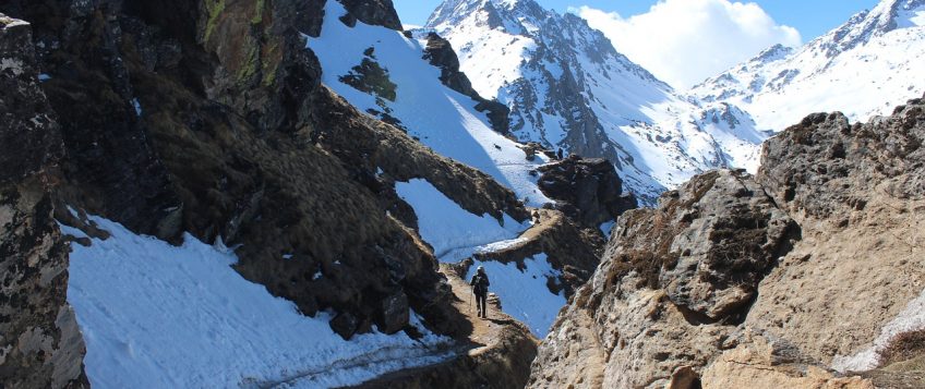
Parts of the old path had been swept away by landslides with the new path crossings across. You will have to cross through 3 landslides, with the biggest one being across where Langtang Village used to be. It is definitely not a pleasant walk through the few hundred meters of Langtang landslide. You will see personal artifacts and old remains from the village sticking up. It looks like you are walking trough a war zone. The path is dodgy and it’s not recommended to stay for long in the landslide area.
After the landslide, there is another 40min – 1hour walk to you reach Mundu.
You will most likely spend at least a night in Mundu.
DAY 4. MUNDU (3543M) – KYANJIN GOMPA (3830M) – MUNDU (3543M) 4.5 HOURS, DAY TRIP, RETURN. 12KM
Kyanjin Gompa is the last settlement in Langtang Valley where is possible to stay, it remains mostly intact with only a few guesthouses damaged from the earthquake. There still are about +10 standing guesthouses.
Kyanjin Gompa was closed down when I walked there. The locals had walked down to SyapruBesi and Kathmandu to celebrate Tibetan new year, but it should be up and running again in late February.
The walk from Mundu to Kyanjin Gompa is a very easy 1.5-hour walk with a few easy acents.
You pass by a Tibetan Stumpa that seems intact after the earthquake after about 1.5 hours of walking. From the Stumpa is it only 30 min more walking to reach Kyanjin Gompa.
Would have loved to stayed in Kanji, but since everything was shut the only option was to return to Mundu, to spend another night there.
The Langtang mountains are seen from Kyanjin GompaLangtang Lirung (Ghone) peak. 7027m. Seen from Kyanjin Gompa
DAY 5. MUNDU (3543M) – SERPAGON (2563M) 7 HOURS. 20 KM.
The same long day as day 3. You will have to walk all the way back to Serpagon since every settlement on the way is either destroyed or closed.
* The locals in Serpagon told us, that at least 1 guesthouse in Rimche would open in late February.
*The first guesthouse you reach when approaching Sherpagon from the Tibetan side “Tibetan Guesthouse” is the best place to stay, every room has attached bathroom and the owners are super friendly.
Easy and flat trough Langtang Valley, on the way to MunduA yack enjoying the view in Langtang Valley
DAY 6. SERPAGON (2563M)- SYAPRUBESI (1503M) 4 HOURS.
Backtracking down same was as you walked on the first day on the hike, nice and easy day with the small settlement of Kangjin being a good place to stop for tea. There is no reason to stress on the way down, you will have to spend a night in SyapruBesi anyway since the only bus back to Kathmandu leaves at 7.30 in the morning.
If you want to something about different from hiking during you visit to Nepal, should you head a few days to Chitwan National Park.
ADDITIONAL INFORMATION ABOUT LANGTANG VALLEY.
Money/Cost.
There’s an ATM in SyapruBesi.
Food – 300 – 550rps. Dhal Bhat 550rps.
Tea – 95 – 120rps each cup.
Coca-Cola – 300rps.
I spend about 1500rps a day on the hike, Langtang Valley is a bit more expensive than Annapurna and the Everest region.
Internet / Electricity.
There’s no WiFi on this hike and you only get phone connection up to Lama Hotel with Ncell.
Don’t count on getting your electronics charged will on the hike, none of the guesthouses I stayed had option of recharging your stuff.
Getting there.
There’s only one buss a day from Kathmandu to SyapruBesi these days. It leaves at 8 am from across the “Buddha Mall” in Kathmandu and arrives at SyapruBesi at around 15.00.
It returns back to Kathmandu from SyapruBesi at 7.30am every morning.
Permits.
You will need to get the normal TIMs card (2000rps) and Langtang National Park entrance permit for 3500rps in Kathmandu before you sett of on the trek. There’s nowhere in SyapruBesi to obtain a TIMs card or permit. There’s 2 checkpoints on the way to SyapruBesi and one just outside of SyapruBesi where your permit will get checked.
Source: unusualtraveler.com
Post a comment
You must be logged in to post a comment.